DREAM Products
- Across the Philippines, water level sensors have been strategically placed to properly monitor and forecast the water level in major and critical rivers. Regularly visit the Water Level Forecast page to know the water level in the rivers near your area and what the predicted water level will be in the next 12 hours. Also, you will find historical data on rainfall and the resulting water level for each river, and cross-section snapshots of certain parts of the river.
- DREAM products cover the 18 major river basins, and will cover more than 200 river basins in the next few years. The LiDAR Coverage page shows which localities already have available LiDAR data.
- Through the use of state-of-the-art technologies, the UP DREAM Program is able to produce three-dimensional information products that have practical applications in the fields of urban planning, agricultural mapping, and disaster preparedness. These products are freely available to local government units. For private entities, on the other hand, approval and recommendation from DOST and UP must first be secured for data request. Some charges may also apply. Products samples are downloadable as well.
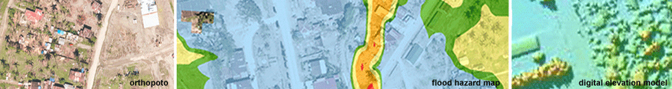
- Flood Hazard Maps show the level of flooding of a particular area during a specific rain return period.
Like Us on Facebook
Facebook